
Canberra's proximity to the bush has always been one of my favourite things about the city, but in light of my relatively newfound love of hiking and being outdoors, that proximity, which can be more aptly described as being wholly encompassed by the bush, has unequivocally become my very favourite thing about the Australian capital.
Canberra is not merely surrounded by the bush, rather built on, around and deeply harmoniously with the bush. It's almost impossible to ever find yourself more than a short walk away from a nature reserve, meaning that getting out and about away from the hustle and bustle of suburbia is incredibly easy. And to make things even better, just to Canberra's south, and a mere 30 - 40 minute drive from the centre of the city, you'll find Namadgi National Park, which is quite frankly an absolute gem of a thing to have on your doorstep. The park is filled with all kinds of tracks, from short 30 minute walks through to multi-day hikes, meaning there truly is something for everyone. This year I've taken it upon myself to uncover some of Canberra's best walks, which has been a deeply enjoyable experience for me, so without further ado, I gift you a shortlist of my absolute favourite walks and hikes in and around Canberra!
Honeysuckle Campground to Booroomba Rocks
Taking out the very prestigious first place in my shortlist of great Canberra walks is the absolute banger of a bushwalk that is Honeysuckle Campground to Booroomba Rocks. I love this walk for many reasons, notably the beautiful, relatively flat meandering trail that passes through some absolutely stunning Australian alpine rainforest, as well as the insane views you get at Booroomba Rocks themselves. It should be noted, while most of the trail is relatively flat and subsequently quite easy, the last 1km or so up to Booroomba Rocks is a solid shlep uphill, though I've seen children easily taking on the challenge, so don't be deterred, merely warned! The views are 100% worth the effort too!
The starting and finishing point for this walk is Honeysuckle Campground, which is around a 1 hour drive from Canberra's CBD. It's easy to find though, you simply head out to Tharwa, down Naas Road and then turn right down Apollo Road. Follow Apollo Road right down to the end of the road, and you'll find yourself at Honeysuckle Campground. There's plenty of parking as well as some toilets there (not to mention, quite often some friendly kangaroos can be found lurking about). The start point for the walk is just to the right of the BBQ area at the front of the campground. The trail is well signposted and maintained, so it's very easy to follow and makes for some really pleasant walking.
The walk is approximately 12km return, and generally takes around 2.5-3 hours, including some time taking in the spectacular view at the top! When you reach the top, you won't actually be at the highest point of the peak, but if you do a bit of bush bashing (i.e. follow the sometimes disguised little trail upwards), you can get to the highest point and enjoy uninterrupted views back towards Canberra. Be careful if you decide to go up beyond the main view point however, as you are on a cliff face, so naturally please exercise caution lest you have a bit of a whoopsie with the edge!
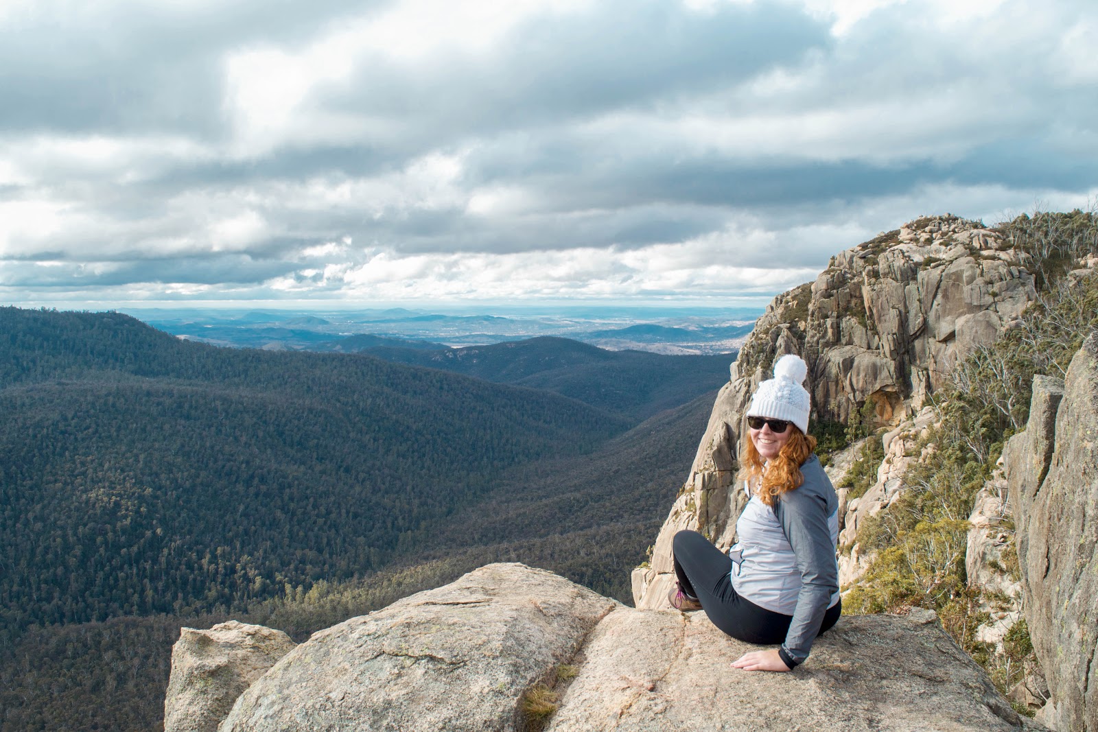 |
| In winter Booroomba Rocks can sometimes have a light dusting of snow, so if you're heading up there during the cooler months, come prepared with a beanie!! |
 |
| Everything the light touches is mine. (Not quite, but a girl can dream/go along with the very empowering emotions that standing on a cliff face with uninterrupted views inevitably brings!) |
Mount Tennent
I first encountered, at the time very unwillingly, the mighty Mount Tennent back in 2010 as part of a school camp. It was not a pleasant experience (I hated every second of hiking the mountain), however the world is a strange place and low and behold here we are a few short years later and to my great surprise, Mount Tennent takes out second place in my list of my favourite Canberra walks. In actual fact, I'm so fond of Mount Tennent these days, that I've actually been up four times already this year, and I intend to double that number of ascents before the year ends! Being a mountain, this is a solid hike, however it's definitely very doable and the views are absolutely worth it!
The starting and finishing point for this walk is the Namadgi Visitors Centre car park which is on Naas Road, just past Tharwa. There's plenty of parking there as well as some toilets and, as the name suggests, a visitors centre full of information should you so wish to visit. To start the walk, go behind the centre towards Naas Road and follow the path till you cross Naas Road. The trail head is just on the other side of the road. I recommend starting out early because it's genuinely one of the greatest feelings ever to enjoy the peace and quiet, plus the endless views from the summit, without anyone else around. This walk is fairly popular with runners and walkers alike, but if you start out around 8am, you should find the walk and summit a little quieter. You'll also be back in Canberra by lunchtime, making this an excellent half day out! Another big benefit of being an early starter is that you'll get to see lots of wildlife around!
The walk is approximately 16km return and takes a solid 4 hours or so, including some mandatory time appreciating that you made it to the summit. The trail is well maintained the whole way up, with a few steeper sections, but as mentioned above, it's totally a doable walk for anyone with moderate fitness and above! It's also an excellent training hike (hence why I've been frequenting it this year) if you've got a longer trip coming up!
 |
| Me, ft. the view towards the south over the wilds of Namadgi National Park. Please note that my shoelace and shirt coordination was unintentional, however nonetheless brings me a ridiculous amount of satisfaction. Also note that the rock I am standing on is an excellent place for some summit tea and a cheeky square of chocolate (sustenance my friends)! |
 |
| The view from halfway up the mountain looking south. |
Shepherds Lookout and the Uriarra Loop
This is my favourite walk to do when I want to be away from town, but I also don't want a big day out. It's around 7km return, relatively easy walking the whole way, has some fun views, gets up all close and personal with the water and, best of all, seems to be a bit of a hidden gem as I've only ever encountered a small number of people while walking this particular walk!
The starting and finishing point for this walk is Shepherds Lookout car park which is on Stockdill Drive in Belconnen and just a short 20 minute drive from the city centre. The car park is just a small little nook on the side of the road, but I've never had an issue finding a place to park. The lookout itself is an easy 5 minute walk from the car park and is quite popular, but few people seem to then take the effort to do the Uriarra Loop walk, which is 100% their loss! After taking in the view of the river from the lookout, keep walking around on the path to your right (if you were facing away from the lookout itself) and after approximately 50m or so you'll see a trail shoot off down into the valley. Follow that down and along the fence line, then across the Molonglo River. On the other side of the Molonglo, turn left, then follow the marked trail up, through the gate, up the small hill, across Uriarra Road and then down to the campground. When at the campground, turn to your right and follow the Murrumbidgee all the way along and eventually you'll end up back at the Molonglo River crossing (if this all sounds a bit confusing, alternatively entirely disregard my ambiguous instructions and just follow the little blue arrow markers that you can find all along this walk)!
The walk is approximately 8km return and takes around 2 hours. It's a really pleasant walk, quite easy (no big hills) and really peaceful, with often the sound of the river the only noise you'll hear!
 |
| The view from the top of Shepherds Lookout, with the Murrumbidgee River winding it's way out of the ACT and into NSW. |
 |
| The trail meanders along the banks of the Murrumbidgee River, which is very peaceful and so refreshing for the soul! |
Mount Ainslie
Literally every Canberran knows that Mount Ainslie is a good walk well worth doing, and despite the track up to the summit generally being a fairly busy one, it's still one of my favourite Canberra walks, partly because of the convenience of it being less than 2km from the city centre and also because I can walk there from my apartment. The actual Ainslie summit walk starts from behind the Australian War Memorial, and while nice, is quite short, so I typically prefer to walk part of the base track that runs around the bottom of the mountain as well, adding in some extra distance with minimal effort (the track around the base is flat, and is actually my regular running track). If wanting to add in some extra distance, heading into the suburb of Ainslie and parking on one of the streets near the mountain is super easy to do and there are heaps of little tracks between the houses that will lead you up and onto the track around the base. Alternatively park behind the War Memorial and head upwards - you'll easily come across the summit trail. Distance will naturally depend on where you decide to start and finish from, so varies because of that.
I seriously recommend heading up Mount Ainslie for sunset. It's probably my favourite place to enjoy the delights of golden hour in the capital and you'll be treated with beautiful views over the entirety of central Canberra and the Parliamentary Triangle. If you're super keen (and also somewhat crazy), this is also a popular trail to run. I however, am a logical human who knows it is a silly idea to run up hills voluntarily so I personally stick to walking!
 |
| Golden hour (literally!) from the Mount Ainslie summit - this view at this time of day will forever be one of my favourite in the whole of Canberra! |
 |
| Telstra Tower and the northern part of Canberra's CBD as viewed from a lookout just down from the summit of Ainslie. |
Corin Dam to Mount Gingera
Finally, on the more serious end of the spectrum is this absolute gem of a hike! Mount Gingera is the ACT's second highest peak, coming in at a solid 1,857m above sea level. It's located right on the edge of the ACT, meaning that from the summit you can views over Canberra's Namadgi National Park and Bimberi Wilderness Area as well as NSW's Kosciuszko National Park too! The summit views are absolutely breathtaking - you get almost uninterrupted 360 degree views of the surrounding country and mountains which is truly something special!
This is a solid hike, coming in just shy of a full day, though if you took your time and had a picnic at the summit or along the way it would become a full day. I did the hike in around 6 hours, but I'd recommend allowing 8 hours just to be safe. This hike starts from the Corin Dam carpark which is on the western side of the dam wall. Drive out over the wall of the dam and you'll find a small carpark on the other side. The trailhead is hard to miss - there's a large Namadgi sign and just further up the trail there's a bushwalking register that I suggest signing before you head off. The first 2 - 2.5km of this hike are HECTIC. You can about 580m of elevation in 2km and lemme tell you that's very wild and you're calves will inevitably have all manner of negative thoughts they'll make known! The first part of this walk is along the 'Stockyard Spur' which I've also heard referred to as the 'Calf Blaster' and truly there has never been a more apt name for a track! While things start out rather steep though, once you make it past the initial 2.5km the track gets a lot flatter, with the bulk of this walk a very pleasant one along a track with soft undulating hills. The walk out is a fairly constant uphill, which makes sense given you're summiting a mountain, but I found it really pleasant, relatively easy walking (aside from the first 2km)! While the first part is quite steep and difficult going, it's 100% worth it - do not be scared off by the baptism of fire that the Stockyard Spur provides!!
After around 7km of walking you'll come to an intersection with Mount Franklin Road. Take a left and keep heading along the road. After around 1km you'll come across the most quaint little hut called Pryor's Hut, which is a working hut that was built in the 1950's. The door to the hut is in the ACT, however the hut itself is in NSW, which I think is super fun. There's a visitor's book inside the hut that you can sign too! This is also a good spot for morning tea/lunch.
After leaving the hut, head back out onto Mount Franklin Road and keep following it for around 1km. You'll be able to see Mount Gingera straight in front of you and it'll be a bit odd to follow the road because it loops around quite obviously to the left, which seems counterintuitive given you want to go up the mountain - don't be fooled though, the summit track actually comes from behind, so follow the road around until you get to a very sharp hairpin turn to the left. That that turn you'll see a wooden pole marking the trail up to the summit on your right - take that path up the last 1km to the summit. Be very careful if you're walking in the warmer months because the trail up to the summit is quite overgrown and snakes are very much around. I strongly suggest wearing gaiters, long pants and appropriate shoes to help reduce the risk of having an overly intimate encounter with one of Gingera's resident snakes! In the springtime there are loads of wildflowers on this last part of the hike, which make for a beautiful atmosphere! The summit trail isn't steep (compared to Stockyard Spur at least!) and I thought it was a pleasant uphill climb to the summit.
When you reach the summit, prepare to have your mind blown by the views. They're insane! You can see all the way to the snowfields and all the way north I could just make out the fountain in Lake Burley Griffin. I spent around an hour at the top just taking in the scenery, it's hands down the best view I've ever had in Canberra!
The walk home is simple - just follow the exact same path you took to get there in reverse! Be particularly careful on Stockyard Spur on the way down - you'll realise just how steep it was coming back!
In winter this area can get quite a lot of snow. This trail is not particularly well marked, which would present a big issue in snow when the trail itself could be obscured. I hiked this is early November and conditions were exceptional - perfect weather and clear skies, so I didn't have a snowy problem but be warned! I'd love to do it again in the winter though, I think it would be something special to see the area in white!
This walk is around 21km in distance. You gain around 900m in elevation from start to summit. Being quite remote, this is much quieter than some of Canberra's other trails. I had the summit entirely to myself, along with the track. Being remote however, make sure you let someone know where you'll be and when to expect you back and prepare appropriately taking extra food, water and warm clothes just in case! Overall this walk was exceptional - while a solid effort, it's 100% worth it! Definitely one of my favourite walks in the Canberra area!
 |
| Stockyard Spur trail, after the initial 2km climb. The majority of this hike is along trail that is like this, through the alpine forest and if you go in spring, through all the wildflowers! |
 |
| Pryor's Hut, the door of which is in the ACT, while the hut itself is in NSW! |
 |
| Standing at the summit, with the ACT in the background behind me. |
 |
| Looking down towards the southern reaches of the ACT over Namadgi National Park and Bimberi Wilderness Area. |
 |
| The wooden pole in the centre of this picture is the marker for the summit trail - as you can see the trail itself is a bit overgrown, but if you pay attention it's easy to follow. Be warned that snakes are a risk in the warmer months though! |
More walks will be added here shortly! I'm currently trialling a few new ones myself and will report back with my findings, so keep checking in for updates!
No comments:
Post a Comment